


The Ealing Animals Fair is organised by Thinking of Animals CIC
Although the information given here is, to the best of the organiser’s knowledge and belief,
correct, the organiser reserves the right to make alterations and amendments, as necessary.
Although the information given here is, to the best of the organiser’s knowledge and belief,
correct, the organiser reserves the right to make alterations and amendments, as necessary.
Please note that there are no car parking facilities
for the general public at the Church.
A map indicating possible local car parking places is
displayed at the foot of this page. If you plan to travel
to the event by car, you may wish to print the map off.
Lidl supermarket car park in the centre of Hanwell approachable from the Uxbridge Road allows free parking for a limited period only (usually up to 3 hours). Please check the signs. The Church is about a 3 minute walk away. Please note that this car park is camera controlled and uses an automatic car number recognition system.
A longer stay is available in the George Street car park which is near Hanwell Clock Tower. As you travel west along the Uxbridge Road, just through the centre of Hanwell traffic lights and past the clock tower, turn left down a narrow road to the car park at the bottom. As well as leading to George Street Car Park, the narrow road is also signposted as leading to Clock Tower Mews. Please see car park notice boards for charges. It will be about a 6 minute walk to the Church from this car park.
The area around the Church and north of the Uxbridge Road is a Controlled Parking Zone (CPZ) which, at present, does not operate on Saturdays (but please check the signs). If it isn’t operating, free on street parking is available around the Church but spaces are limited due to residents’ parking unless you move further away from the Uxbridge Road. But please check the signs.
Click on the Bus stop map button for a local map showing bus routes. Click on the Google map button for an external map of the surrounding area.
Please note that charges and conditions for parking may change.

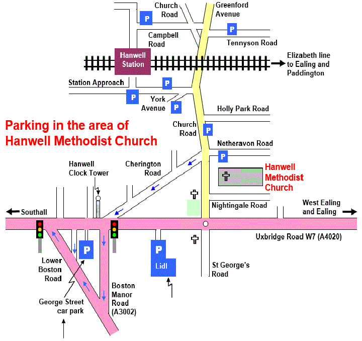
Please check the car parking signs for changes to
parking hours and cost before you
park.
This map is not drawn to scale.
This is the car park you are very likely to get in but the entrance is narrow so be careful not to miss it. Please refer to the notice boards for charges.
As well as the sign leading to George Street Car Park, it is also signposted leading to Clock Tower Mews.
Lidl car park -
3 hours free but beware it is camera controlled.
Parking Restrictions
Apart from Lidl’s car park and George Street car park, the symbols on this map represent where you can look for on street parking. Restrictions vary considerably so check the signs.
P
| Map |
| Car parking |
| Subject Index |